Sleepy Creek Ranch SHARE Hunt


Sleepy Creek Ranch Deer & Pig SHARE Hunt

Recently I put in for a SHARE hunt drawing through the Department of Fish and Wildlife’s website (online licensing). “The SHARE Program is designed to improve public access to private or landlocked public land. Participating landowners will be compensated with monetary payment and liability protection for providing access to or through their land for recreational use and enjoyment of wildlife. SHARE is funded with SHARE Access Permit Application fees.” More info at: www.wildlife.ca.gov/hunting/share.

I have to say, my experience up to this point has been extremely pleasant. I was notified via e mail by CDFW that I had been drawn for the hunt. I was sent all the pertinent information needed for the hunt, all of my questions were answered promptly and politely by the CDFW staff Victoria Barr and Mitch Soto.

The Sleepy Creek Ranch is located in the West Cuyama Valley, Santa Barbara County, CA. The homestead was originally built in 1985, but now serves as a bed and breakfast or vacation rental for recreational users and the occasional lucky SHARE Hunt Program participant. The B&B known as “The Little Red House” is a modern B&B with a choice of three guest rooms. The ranch is described on their website as a 700-acre ranch that “offers miles of trails through oak savannahs, riparian habitat, juniper-sage woodlands and chaparral. It’s a hidden gem for springtime wildflowers, a busy flyway for migratory birds, as well as a resident population of wild turkey and occasional California Condor visits.” I encourage anyone reading this to visit their website: www.sleepycreekranch.com. I haven’t been to the ranch yet, but my conversations with the host Bonnie Goller have left me excited about this trip. She was very polite, informative, and accommodating on the phone.

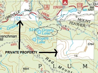
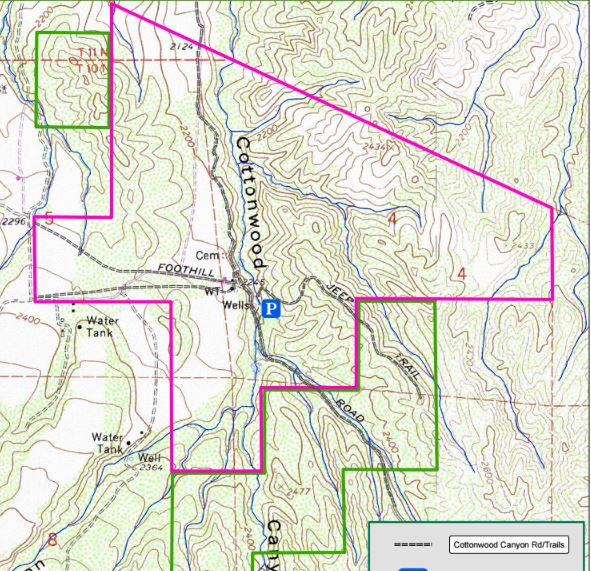
This will be an exciting trip. On my other posts about planning your Deer hunt, you, the hunter, are making all the decisions on where and how you will hunt. Here We will need to be respectful of any rules or requests by the landowner which may or may not impact our hunting strategy. Since we cannot go ahead of time to scout the area in person our scouting will have to be done all online. Below is the topo map that was sent by CDFW. It gives a general terrain description and property boundaries. What’s important to note from this map is the elevation. We’ll be hunting around 2200’. There are no weather stations nearby, so I will be using the weather from Bakersfield and subtract 3.5 degrees for every 1,000 ft. of elevation to get an approximate weather forecast for the ranch. As it stands right now this will be a typical HOT California archery hunt in the 90-100 degree range.

sleepytopo

Other resources I’m using for this hunt are Google Earth, OnX Hunt app, and any open source information I can find online. So far, there is very little information about hunting this property. Google Earth and the OnX Hunt app will show similar information, but the On X Hunt app will use your phone’s GPS capability to tell you where you are and show you the property lines. This is extremely important when you’re hunting someone else’s property. Your phone does not have to have cell service for the OnX Hunt app to work. The cost is $35.00 a year for premium map layers and well worth the investment in my opinion.

The third source of information for the hunt was from Bonnie when I called to reserve a room for my Wife and I. She provided some invaluable information about where she sees game on the property and what other hunters have seen. According to Bonnie there’s at least one big Pig on the property, she has seen a couple spike Bucks, a couple other smaller Bucks, and there are also a couple Bears that frequent the property. Unfortunately for me it will not be Bear season during our hunt. Bonnie, being the great host that she is, said she would start keeping notes on where and when she sees game on the property and leave the notes for when we arrive (Bonnie will be out of town during our hunt).

Stay tuned for Part 2!

Planning Your Deer Hunt Part 3.

Sorry I’ve been away for so long. Real life keeps me extremely busy, but hopefully from here on out I will be able to get on fairly regularly to post about upcoming hunting and fishing trips!

D-3, Bucks Lake, time to get some boots on the ground and see the area. Scouting. I took my daughter up to the lake for a little fishing and a closer look. The lake and surrounding area was nice. The terrain was really steep and rugged though. Access to any areas that weren’t private seemed to be limited. The lake reminded me of a smaller Lake Tahoe. The lake itself has a road going around it which is lined with what appeared to be vacation rentals. It looked like it might be a good place to make a base camp out of one of the cabin rentals, then travel somewhere nearby to hunt. The lake itself and the immediate area didn’t seem conducive to hunting.

That’s part of scouting though. That’s why we scout. Do your internet scouting first, then get some boots on the ground to have a look. For me, the terrain wasn’t what I was looking for, there were too many people, too much paved road for what I want to hunt. I have some other hunting opportunities coming up, so I think I will pass on D-3 this year. Stay tuned.


Planning Your Deer Hunt Pt.2

bucks lake

Before we start driving for hours you should definitely be leveraging the resources you have available before you get there. Some “pre-scouting” if you will. Most people’s first stop is Google Earth and why not? It’s a great resource.

Bucks Lake Earth2

One of the things I quickly learned is this seems to be a heavily used lake. There’s a marina, cabins, boat rentals, several camp grounds all around the lake. This could mean many different things.. The deer may be used to people and stay in the area or it may pressure them away. IF I hunt this area I’m unsure at what time during the season I will hunt it. I will plan as if I’m going to hunt late in the season, which means this area will be heavily pressured.

Bucks Lake roads

As you can see from the above photo there are several roads zig zigging through the entire area. This is not a good sign for late season hunting. This area will likely be heavily traveled by road hunters and OHV users. Road hunters are people who’s idea of hunting is driving around until you see a deer and then shooting it, often times from the road. Shooting from the road, unless you are disabled, with the proper permit, is illegal and unethical.

roads

We may be able to leverage this road hunting and general access pressure to our advantage. Below the lake is an area with very little vehicle access and it also has a pond in the upper left part of the circle. The arrows represent the potential pressure being placed on the deer by vehicle traffic.

Let’s take a closer look at that pond. In the summer time that pond may provide some relief for wildlife not wanting to go near the people at the lake. This would be a good place to look for deer trails. I would not set up on the pond itself because doing so would pressure other wildlife away from the water which they need to survive the hot summers. Instead look for access trails and try to find where you can intercept them on their way to/from the pond.

Scout2

A lot of the lower lake’s property is private, we still need to make sure this is area is public property. Below is a snip from http://www.fs.usda.gov/Internet/FSE_DOCUMENTS/stelprdb5323336.pdf

private

It’s hard to tell from the above map. I will have to reference my On X Hunt map which will tell me for sure.

EDIT: I was able to look on my OnX HUNT app and the “pond” is not private property. It’s actually called Grizzly Lake, but from the severe drought we’ve had it appears to be just a pond now. I highly recommend the OnX HUNT app.  Let there be no doubt about where you’re hunting. I will review the app in a separate post. I hope to get a screen shot of the app up at some point, but for now here is a topo map showing the lake in relation to the surrounding private properties.

grizzly lake

Stay tuned. Hopefully we can actually get up to the lake soon.


Planning Your Deer hunt Pt. 1

zone map

Hunting is one of the most rewarding things I get to do on a regular basis. When was the last time you saw someone go to the store, buy a steak, and say “man, I worked SO hard to get this!” Said no one ever. If you follow along with this blog you will see that hunting is not a weekend trip where someone walks in the woods and just shoots a deer. Hunting takes months, if not years, of hard work. Finding your prey, learning about them, spending significant resources to pursue them. So follow along and lets work and learn together.

I wanted to touch on some strategies I use when I’m considering a big game hunt. I’m going to assume most of you who are reading this are California natives. I can’t imagine why someone would pay a non-resident fee to hunt in our state, but you never know. Personally if I’m going to pay that kind of money I’m going to Montana or Wyoming, but that’s just me.

It’s early May, 2016, now so you need to make sure you get your applications in by June 2, 2016. If it’s after June and you’re reading this article don’t fret, you can still get plenty of good over the counter tags. For the purposes of this article all references will be from http://www.wildlife.ca.gov.

One of the first places you should look is the harvest reporting statistics from the most recent year. This will give you an idea of where the higher populations of deer are, but you will also need to factor in the availability of public access. We will look at Deer Zone D3-5. The season is from September 24, 2016 – October 30, 2016. This is an area with a high amount of tags issued (33,000), making the reported hunter success seem low (6.5%), but when you look at the total number of deer taken (2,146) it’s one of the highest in the state. You should note that when looking at the table below the column to the right containing the higher numbers are not the actual numbers reported, but estimates of what DFW thinks are real numbers. For instance 2,146 people reported their deer kill, but DFW believes approximately 5,822 deer were killed. That’s a big difference… I don’t know how they get that estimate, but I am curious.

D3-5

Keep in mind this zone had 33,000 tags issued in 2014. That’s a lot of people who will be in your hunt area. To hunt this zone it will be imperative that you get out and SCOUT. You will have to do it. Period. So our goal here will be to find an area with good public access, yet is remote enough to allow us to get away from other people.

The area we are going to look at is in the D3 portion of the zone, in the Plumas National Forest. It’s an area called Bucks Lake. I like the name.. I have never hunted this area, so this will be a new experience for all of us. You should start your scouting early, we may get up to Bucks Lake and find that it’s incredibly crowded or it has poor access. So, we want to make sure we have enough time to adjust to a new location.

bucks lake

As we continue in this series we will start to do specific research on the Bucks Lake area and then physically go there if our research proves promising.

To be continued…